


francis 2

emodentine
User
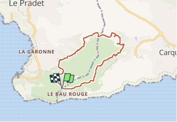

Length
7.3 km

Max alt
204 m

Uphill gradient
184 m
Km-Effort
9.8 km

Min alt
64 m

Downhill gradient
184 m
Boucle
Yes
Creation date :
2025-08-06 05:12:18.607
Updated on :
2025-08-06 08:42:07.859
3h29
Difficulty : Medium

FREE GPS app for hiking
 SityTrail
IGN / Geographical institutes
SityTrail Plus
The world is yours!
About
Trail Walking of 7.3 km to be discovered at Provence-Alpes-Côte d'Azur, Var, Le Pradet. This trail is proposed by emodentine.

Positioning
Country:
France
Region :
Provence-Alpes-Côte d'Azur
Department/Province :
Var
Municipality :
Le Pradet
Location:
Unknown
Start:(Dec)
Start:(UTM)
258630 ; 4774148 (32T) N.
Comments